Trail Walking Le Tholonet - le tour des barrages - Photo
 amiral13
amiral13

User GUIDE

© OpenStreetMap contributors
Length
Length
10.9 km
Max alt
Max alt
374 m
Uphill gradient
Uphill gradient
345 m
Km-Effort
Km-Effort  
15.5 km
Min alt
Min alt
180 m
Downhill gradient
Downhill gradient
348 m
Boucle
Boucle
Yes
Creation date :
2015-04-01 00:00:00.0
Updated on :
2015-04-01 00:00:00.0

(1 Reviews)

Walking
Walking
6h04
Difficulty : Easy

Scan this QR Code to open this trail in the SityTrail application

FREE GPS app for hiking

Logo SityTrail SityTrail

IGN / Geographical institutes

Download SityTrail from the App Store Download SityTrail from Google Play

Logo SityTrail SityTrail World

The world is yours!

Download SityTrail from the App Store Download SityTrail from Google Play Download SityTrail on Huawei AppGallery

About

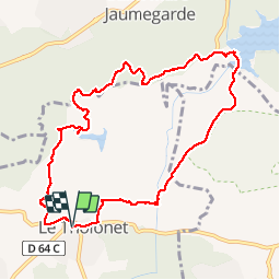
Trail Walking of 10.9 km to be discovered at Provence-Alpes-Côte d'Azur, Bouches-du-Rhône, Le Tholonet. This trail is proposed by amiral13.

Description

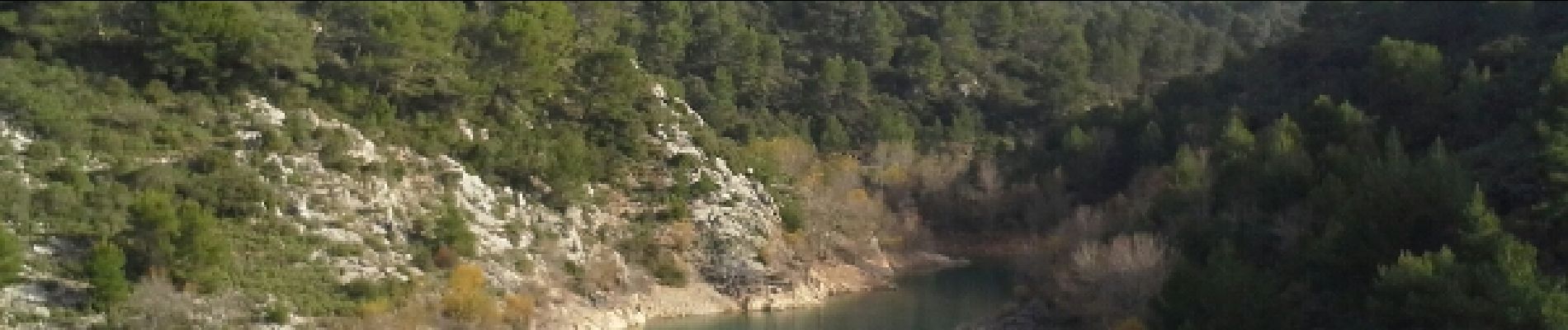
une jolie randonnée qui vous permettra de passer au niveau des barrages Zola et du Bimont.
sur le trajet retour après la côte 362 ne pas suivre notre parcours tout droit mais emprunter la piste qui part au nord ouest avant de revenir vers le sud-ouest.
rando effectuée avec des enfants de 6 ans aguerris

Elevation profile

Photos

Positioning

Country:
France
Region :
Provence-Alpes-Côte d'Azur
Department/Province :
Bouches-du-Rhône
Municipality :
Le Tholonet
Location:
Unknown
Start:(UTM)
702879 ; 4821828 (31T) N.

Comments

Please log in to post a review or rate the element


le chemin en balcon entre les 2 barrages est absolument mythique!


Trails nearby

Trail Walking Aix-en-Provence - Circuit des lacs Zola et Bimont - Aix-en-Provence - Photo
Walking
tracegps

Walking

Medium
(4)
Aix-en-Provence, Provence-Alpes-Côte d'Azur, Bouches-du-Rhône, France
10 km | 13.6 km-effort
2h 30min
Yes
Trail Walking Saint-Marc-Jaumegarde - Barrages Zola-Bimont - Photo
Walking
Berpav

Walking

Medium
(2)
Saint-Marc-Jaumegarde, Provence-Alpes-Côte d'Azur, Bouches-du-Rhône, France
8 km | 11 km-effort
2h 30min
Yes
Trail Walking Saint-Marc-Jaumegarde - La Croix de Provence depuis le barrage de Bimont - Photo
Walking
tracegps

Walking

Difficult
(1)
Saint-Marc-Jaumegarde, Provence-Alpes-Côte d'Azur, Bouches-du-Rhône, France
13.9 km | 24 km-effort
4h 45min
Yes
Trail On foot Beaurecueil - Sentier Imoucha - Photo
On foot
PRO

On foot

Easy
Beaurecueil, Provence-Alpes-Côte d'Azur, Bouches-du-Rhône, France
4.4 km | 10.1 km-effort
2h 17min
No
Trail Walking Aix-en-Provence - Aix En Provence - St Beaume - Photo
Walking
Geckos

Walking

Difficult
(1)
Aix-en-Provence, Provence-Alpes-Côte d'Azur, Bouches-du-Rhône, France
65 km | 94 km-effort
19h 29min
No
Trail Walking Saint-Antonin-sur-Bayon - Sainte Victoire - Bau Cézanne - tracé jaune - Photo
Walking
GUIDE
amiral13

Walking

Difficult
(1)
Saint-Antonin-sur-Bayon, Provence-Alpes-Côte d'Azur, Bouches-du-Rhône, France
5.3 km | 12.2 km-effort
2h 28min
Yes
Trail Walking Saint-Antonin-sur-Bayon - Sommet Croix de Provence - Barrage du Bimont - Photo
Walking
GUIDE
lhomme.ph

Walking

Medium
Saint-Antonin-sur-Bayon, Provence-Alpes-Côte d'Azur, Bouches-du-Rhône, France
14.2 km | 25 km-effort
5h 3min
Yes
Trail Walking Aix-en-Provence - Randonnée des barrages Zola et Bimont - Photo
Walking
dudu42

Walking

Medium
Aix-en-Provence, Provence-Alpes-Côte d'Azur, Bouches-du-Rhône, France
10.4 km | 14 km-effort
2h 22min
Yes
Trail Walking Le Tholonet - Le Tholonet -La Croix de Provence Par les Lacs Zola et Bimont - Photo
Walking
donda

Walking

Very difficult
Le Tholonet, Provence-Alpes-Côte d'Azur, Bouches-du-Rhône, France
21 km | 34 km-effort
6h 17min
Yes


Close
My subscriptions